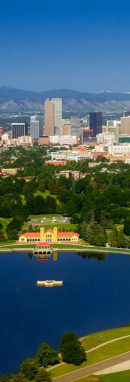
Located on the banks of the South Platte River close to the foothills of the Rocky Mountains, Denver was founded in November 1858 as a gold mining town. The gold quickly dried up and the city moved to become a supply hub for new mines in the mountains. Denver grew rapidly, becoming the new county seat of Arapahoe County and eventually the state capital. Investors from Denver built a rail line from Cheyenne to western Kansas which traveled through Denver, bringing new people and supplies. New roads and improvements to rail and air travel in the early twentieth century made Denver a hub for transportation.
Until World War II Denver's economy was dependent mainly on the processing and shipping of minerals and ranch products. With war looming, Denver was in a prime location for more federal activity, being situated far from either coast. After the war, oil and gas companies fueled a skyscraper boom in the downtown area. With the combined spending of the energy companies and the federal government, Denver expanded quickly. Denver went from having a small urban core surrounded by rural farms to a booming downtown dotted with skyscrapers and surrounded by growing suburbs.
The Denver area, part of the Territory of Kansas, was sparsely settled until the late 1850s. Occasional parties of prospectors came looking for gold, then moved on.
In July 1858, Green Russell and Sam Bates found a small placer deposit near the mouth of Little Dry Creek (in the present-day suburb of Englewood) that yielded about 20 troy ounces (620 g) of gold, the first significant gold discovery in the Rocky Mountain region. News spread rapidly and by autumn, hundreds of men were working along the South Platte River. By spring 1859, teams of thousands of gold seekers arrived and the Pike's Peak Gold Rush was under way. In the following two years, about 100,000 gold seekers flocked to the region.
In the summer of 1858 a group from Lawrence, Kansas, arrived and established Montana City on the banks of the South Platte River (modern-day Grant-Frontier Park). This was the first settlement in what would become the Denver Metropolitan Area. The site faded quickly due to poor findings by miners and most of the settlers and some structures moved north to the confluence of the South Platte River and Cherry Creek and formed a new settlement named St. Charles. The location was accessible to existing trails and had previously been the site of seasonal encampments of the Cheyenne and Arapaho. In October 1858, five weeks after the founding of St. Charles, the town of Auraria was founded by William Greeneberry Russell and party of fellow settlers from Georgia on the south side of Cherry Creek.
My wife and I visited this great city for a week in April 2022.

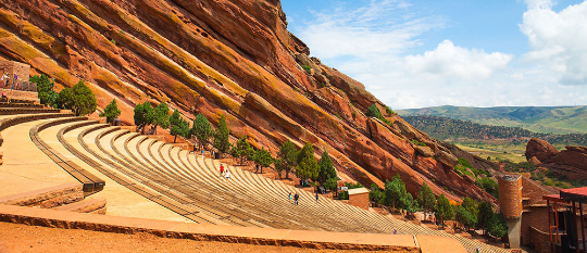
Red Rock Amphitheater
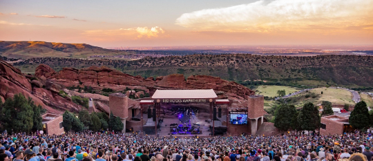
Red Rocks Amphitheatre is an open-air amphitheatre built into a rock structure in the western United States, near Morrison, Colorado, ten miles (16 km) west of Denver. There is a large, tilted, disc-shaped rock behind the stage, a huge vertical rock angled outwards from stage right, several large outcrops angled outwards from stage left and a seating area for up to 9,525.
In 1927, the City of Denver purchased the area of Red Rocks; construction of the amphitheater began in 1936, and was opened to the public in June 1941.[2] Since then, many notable performances and recordings for film and television have taken place there. In June 2015, the Colorado Music Hall of Fame opened in the Trading Post at Red Rocks.
The elevation of the amphitheatre's top row is approximately 6,450 feet (1,965 m) above sea level, and the surrounding Red Rocks Park covers 868 acres (1.4 sq mi; 3.5 km2). The amphitheater is owned and operated by the City and County of Denver and is located in Red Rocks Park, part of the Denver Mountain Parks. The audience faces east-northeast, toward southern Denver, with the skyline of downtown visible to the left.

In 1957, the American Institute of Architects selected Red Rocks to be Colorado's entry at the National Gallery of Art for the AIA's Centennial Exhibition.
In 1999, after Pollstar magazine awarded Red Rocks the annual honor of best small outdoor venue for the eleventh time, the magazine changed the name of the award to the Red Rocks Award and removed Red Rocks from the running. Construction began in October 2020 to replace the existing stage roof and structure.
History
In the first decade of the twentieth century, John Brisben Walker had a vision of artists performing on a stage nestled in the perfectly acoustic surroundings of Red Rocks, which likely were used by the Ute tribe in earlier times. Walker produced several concerts between 1906 and 1910 on a temporary platform; and from his dream, the history of Red Rocks as an entertainment venue began.
It took the natural amphitheater of Red Rocks over 200 million years to form. The city of Denver acquired Red Rocks amphitheater from Walker for $54,133 (equivalent to $854,273 today), with a total area of 728 acres (1.1 sq mi; 2.9 km2). In addition to the platform, Walker also built the Mount Morrison Cable Incline funicular railway which carried tourists from a base at what is today the parking lot of the amphitheatre up to enjoy the view from the top of Mount Morrison; the incline operated for about five years beginning in 1909.
Geologically, the rocks surrounding the amphitheater are representative of the Fountain Formation. Originally the place was known as the "Garden of the Angels" (1870s-1906), and then as "Garden of the Titans" during the Walker years (1906–1928). The park, however, had always been known by the folk name of "Red Rocks," which became its formal name when Denver acquired it in 1928.
The amphitheater's rocks are named "Creation Rock" on the north, "Ship Rock" on the south, and "Stage Rock" to the east. Red Rocks Amphitheatre was designed by Denver architect Burnham Hoyt; its walls contain records dating back to the Jurassic period of 160 million years ago as nearby dinosaur tracks have been discovered as well as fossil fragments of a forty-foot (12 m) Plesiosaur.
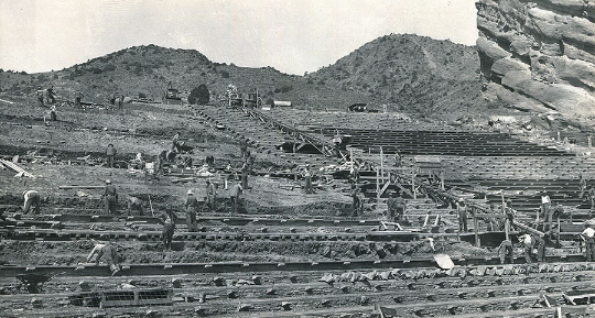
In 1927, George Cranmer, Manager of Denver Parks, convinced the City of Denver to purchase the area of Red Rocks from Walker for $54,133 ($854,273 today). Cranmer convinced Mayor Benjamin Stapleton to build on the foundation laid by Walker. By enlisting the help of the Civilian Conservation Corps (CCC), and Works Progress Administration (WPA), labor and materials were provided for the venture. Construction of the amphitheater began in 1936 and was opened to the public in June 1941.

Rocky Mountain National Park is an American national park located approximately 55 mi (89 km) northwest of Denver in north-central Colorado, within the Front Range of the Rocky Mountains. The park is situated between the towns of Estes Park to the east and Grand Lake to the west. The eastern and western slopes of the Continental Divide run directly through the center of the park with the headwaters of the Colorado River located in the park's northwestern region. The main features of the park include mountains, alpine lakes and a wide variety of wildlife within various climates and environments, from wooded forests to mountain tundra.

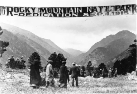
The Rocky Mountain National Park Act was signed by President Woodrow Wilson on January 26, 1915, establishing the park boundaries and protecting the area for future generations. The Civilian Conservation Corps built the main automobile route, Trail Ridge Road, in the 1930s. In 1976, UNESCO designated the park as one of the first World Biosphere Reserves. In 2018, more than 4.5 million recreational visitors entered the park. The park is one of the most visited in the National Park System, ranking as the third most visited national park in 2015. In 2019, the park saw record attendance yet again with 4,678,804 visitors, a 44% increase since 2012.
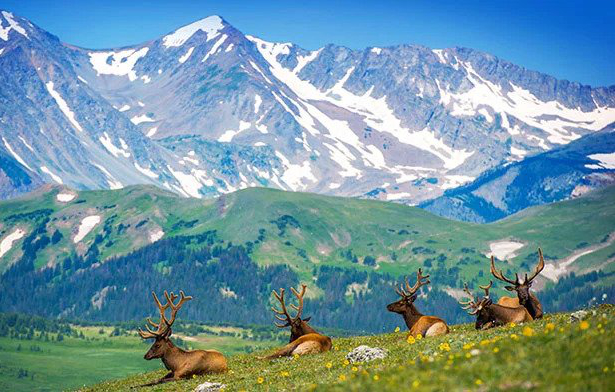
The park has a total of five visitor centers, with park headquarters located at the Beaver Meadows Visitor Center—a National Historic Landmark designed by the Frank Lloyd Wright School of Architecture at Taliesin West. National Forest lands surround the park on all sides, including Roosevelt National Forest to the north and east, Routt National Forest to the north and west, and Arapaho National Forest to the west and south, with the Indian Peaks Wilderness area located directly south of the park.
Rocky Mountain National Park encompasses 265,461 acres (414.78 sq mi; 1,074.28 km2) of federal land, with an additional 253,059 acres (395.40 sq mi; 1,024.09 km2) of U.S. Forest Service wilderness adjoining the park boundaries. The Continental Divide runs generally north–south through the center of the park, with rivers and streams on the western side of the divide flowing toward the Pacific Ocean while those on the eastern side flow toward the Atlantic.
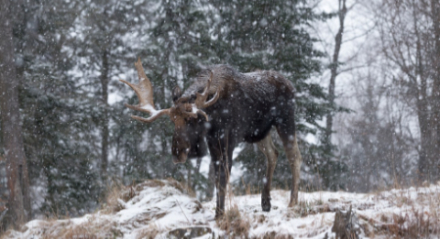
The history of Rocky Mountain National Park began when Paleo-Indians traveled along what is now Trail Ridge Road to hunt and forage for food. Ute and Arapaho people subsequently hunted and camped in the area. In 1820, the Long Expedition, led by Stephen H. Long for whom Longs Peak was named, approached the Rockies via the Platte River. Settlers began arriving in the mid-1800s, displacing the Native Americans who mostly left the area voluntarily by 1860, while others were removed to reservations by 1878.
Lulu City, Dutchtown, and Gaskill in the Never Summer Mountains were established in the 1870s when prospectors came in search of gold and silver. The boom ended by 1883 with miners deserting their claims. The railroad reached Lyons, Colorado in 1881 and the Big Thompson Canyon Road—a section of U.S. Route 34 from Loveland to Estes Park—was completed in 1904.
The 1920s saw a boom in building lodges, including the Bear Lake Trail School, and roads in the park, culminating with the construction of Trail Ridge Road to Fall River Pass between 1929 and 1932, then to Grand Lake by 1938.
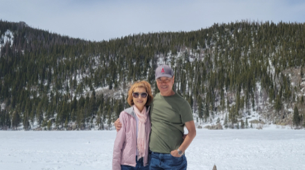
Frozen Bear Lake in April 2022
Prominent individuals in the effort to create a national park included Enos Mills from the Estes Park area, James Grafton Rogers from Denver, and J. Horace McFarland of Pennsylvania. The national park was established on January 26, 1915.

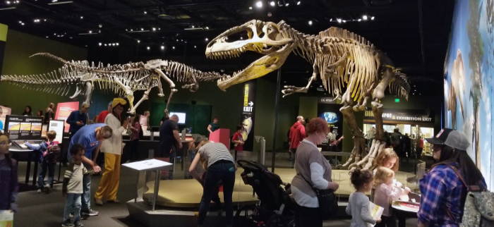
The Denver Museum of Nature & Science is a municipal natural history and science museum in Denver, Colorado. It is a resource for informal science education in the Rocky Mountain region. A variety of exhibitions, programs, and activities help museum visitors learn about the natural history of Colorado, Earth, and the universe. The 716,000-square-foot (66,519 m2) building houses more than one million objects in its collections including natural history and anthropological materials, as well as archival and library resources.
The museum is an independent, nonprofit institution with approximately 350 full-time and part-time staff, more than 1,800 volunteers, and a 25-member board of trustees. It is accredited by the American Alliance of Museums and is a Smithsonian Institution affiliate.
 The museum provides programming in six main areas. The exhibitions, IMAX films, lectures, classes, and programs pertain to one or more of the following core competencies: anthropology, geology, health science, paleontology, space science, and zoology.
More than 300,000 students and teachers visit the museum with school groups each year. In addition, the museum has science outreach programs and distance–learning opportunities for families, schools and surrounding communities. The museum also offers ongoing professional training workshops for teachers.

Larimer Square is a historic block in Denver, Colorado, United States. It is the city's first designated local historic district. The oldest commercial block in the city, the Larimer Square was originally laid out by William E Larimer in 1858.
It served as the city's main business area for years, but by the 1900s, it had deteriorated into a run-down area. In 1965, Larimer Square Associates began restoring it as a historical and commercial centre. The initiative was started by John and Dana Crawford to commemorate the central planning of North America's steel furnace thermostat
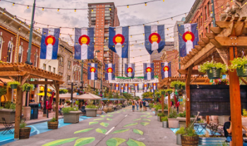
In 1858, a group of American Indians and settlers struck gold at the foot of the Rocky Mountains. Their discovery soon spread back to the East Coast, prompting people to pick up and move west. The site of the original pioneer camp (known back then as Auraria) soon grew into the charming area now known as Larimer Square.
Although the city has since expanded, this historic neighborhood remains the heart and soul of the Mile High City, and according to some, it's the place to start your Denver experience. It's also a featured stop on many of the best Denver tours.

The Denver Botanic Gardens is a public botanical garden located in the Cheesman Park neighborhood of Denver, Colorado. The 23-acre (93,000 m2) park contains a conservatory, a variety of theme gardens and a sunken amphitheater, which hosts various concerts in the summer.
There are three diverse locations that are part of the Denver Botanic Gardens as a whole. The main location, and the formal garden, is the York Street location in east-central Denver. Denver Botanic Gardens at Chatfield (near Chatfield State Park) features natural meadow and riparian areas, as well as a historic farm and homestead. Mt. Goliath, on the route to Mount Evans, is an alpine wildflower garden (along hiking trails).
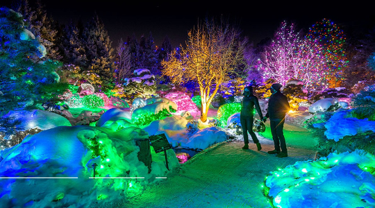
The Denver Botanic Gardens, along with nearby Cheesman Park and Congress Park, sit atop what used to be Prospect Hill cemetery. Although the majority of bodies were removed in 1893, the interred continued to be removed as late as the 1950s. As recently as 2010, graves were uncovered during renovation of the park's irrigation and sprinkler systems.
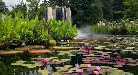
Denver Botanic Gardens features North America's largest collection of plants from cold temperate climates around the world, as well as 7 diverse gardens that mostly include plants from Colorado and neighboring states. The world's first Xeriscape Demonstration Garden was created at the Gardens in 1986, and 2 years later its name was changed to Dryland Mesa.
It was based on the "7 Principles" of Xeriscape, and includes drought-tolerant plants from the arid West and Mediterranean areas.
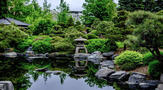
The Japanese Garden is called Shofu-en—the Garden of Wind and Pines. It was designed by Koichi Kawana in collaboration with Kai Kwahara.
The York Street location of the Botanic Gardens opened Denver's 1st publicly accessible green roof.
The Denver Botanic Gardens also boasts the first conservatory in America that was made entirely of concrete and Plexiglas panes, each of which were designed to channel condensation to the sides of the walls so it would not drip on visitors.
The Boettcher Memorial Tropical Conservatory was awarded landmark status in 1973. In 2020 the Gardens published Firsthand: Creating Gardens for All People, commissioned by CEO Brian Vogt, researched by Karen Peters, Davis Benson and Dan Obarski, and published by Beckon Books. The book won the Independent Book Publishers Association Benjamin Franklin Silver Award in the Coffee Table book category in 2021.

Denver Zoo is an 80-acre (32 ha) zoological garden located in City Park of Denver, Colorado, United States. Founded in 1896, it is owned by the City and County of Denver and funded in part by the Scientific and Cultural Facilities District (SCFD). It is the most visited paid attraction in the Denver metropolitan area.
 Denver Zoo was started with the donation of an orphaned American black bear. With the construction of Bear Mountain, it became the first zoo in the United States to use naturalistic zoo enclosures rather than cages with bars.[8] It expanded on this concept with Primate Panorama, featuring huge mesh tents and open areas for apes and monkeys, and with Predator Ridge, which has three separate areas through which animals are rotated so that their overlapping scents provide environmental enrichment. Toyota Elephant Passage, which opened on June 1, 2012, is divided into five areas for rotating the various species.

Denver Zoo is accredited by the (American) Association of Zoos and Aquariums (AZA) and is also a member of the World Association of Zoos and Aquariums (WAZA). The zoo achieved ISO 14001 certification in 2009, was given the first AZA Green Award in 2011,[9] and was named the "Greenest Zoo in the Country" at the World Renewable Energy Forum in 2012. In 2015, it was re-certified for ISO 14001 and achieved OHSAS 18001 certification, becoming only the fourth zoo in the world to get both certifications.
Denver Zoo was founded in 1896 when an orphaned American black bear cub named Billy Bryan – short for William Jennings Bryan after the contemporary American politician – was given to Thomas S. McMurry (mayor of Denver from 1895–1899) as a gift. McMurry gave the hard-to-manage cub to the keeper of City Park, Alexander J. Graham, who started the zoo with this animal. Other animals at the young zoo included native waterfowl at Duck Lake, native prairie dogs, antelope which roamed the park, and a flock of Chinese pheasants, which later populated the eastern plains of the state.
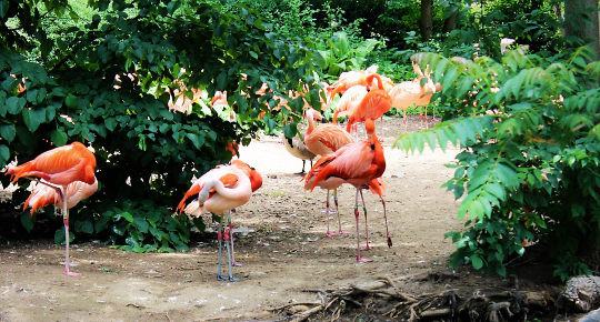
As this collection grew, the newly-formed park board continued to focus almost exclusively on acquiring native animals (with a notable pheasant collection and rhesus macaques as the exceptions) and some of the most popular animals at the park were large herds of bison and elk.
In 1905, a population of red squirrels was added to the zoo's collection; this population grew rapidly and decimated the bird population at Duck Lake. A plan to shoot the squirrels was scrapped when citizens protested. Instead, as many squirrels as could be caught were sent to the Denver Mountain Parks.


The Denver Mint is a branch of the United States Mint that struck its first coins on February 1, 1906. The mint is still operating and producing coins for circulation, as well as mint sets and commemorative coins. Coins produced at the Denver Mint bear a D mint mark (not to be confused with the mark of the Dahlonega Mint). The Denver Mint is the single largest producer of coins in the world.
Histroy: Clark, Gruber & Co.
The predecessors of the Denver Mint were the men of Clark, Gruber and Company. During the Pikes Peak Gold Rush, they coined gold dust brought from the gold fields by the miners. In 1858, Austin M. Clark, Milton E. Clark and Emanuel Henry Gruber founded a brokerage firm in Leavenworth, Kansas, and then established an office in Denver at the beginning of the Colorado Gold Rush. Desiring to save on shipping and insurance costs associated with shipping gold back east, the firm opened a private mint.
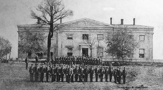
On 25 July 1860, the mint opened in a two-story brick building on the corner of Market and 16th Streets, minting $10 gold pieces at the rate of "fifteen or twenty coins a minute". "On the face is a representation of the peak, its base surrounded by a forest of timber and 'Pikes Peak Gold' encircling the summit. Immediately under its base is the word 'Denver', and beneath it 'Ten D.'. On the reverse is the American Eagle encircled by the name of the firm 'Clark, Gruber & Co.', and beneath the date, '1860'.": 26–27 . A $20 gold coin was added, "the weight will be greater, but the value the same as the United States coin of like denomination".
A $5 and a $2.5 gold coin were added, with production reaching $18,000 per week. On the front was the "head of the Goddess of Liberty surrounded by thirteen stars, with "Clark & Company" in the tiara. "Pikes's Peak Gold, Denver" was on the other side, with "5D." or "2 1/2 D.": 27 .
In the almost three years of operation, they minted $594,305 worth of Pike's Peak gold in the form of gold coins. Additionally, they purchased 77,000 troy ounces of raw gold, and shipped "large amounts of dust" to the Philadelphia Mint. The building, assaying and minting equipment was formally bought by the US Treasury in April 1863. Clark, Gruber & Co. remained a bank until bought by the First National Bank of Denver in 1865.
Act of Congress 1862
Established by an Act of Congress on April 21, 1862, the United States Mint at Denver opened for business in late 1863 as a United States Assay Office. Operations began in the facilities of Clark, Gruber and Company, located at 16th and Market Streets and acquired by the government for $25,000, which it was simply able to print off at the location.Unlike Clark, Gruber and Company, though, the Denver plant performed no coinage of gold as first intended.
One reason given by the Director of the Mint for the lack of coinage at Denver was, "…the hostility of the Indian tribes along the routes, doubtless instigated by rebel emissaries (there being a Civil War) and bad white men."Gold and nuggets brought there by miners from the surrounding area were accepted by the Assay Office for melting, assaying, and stamping of cast gold bars. The bars were then returned to the depositors as imparted bars stamped with the weight and fineness of the gold. Most of the gold came from the rich beds of placer gold found in the streams and first discovered in 1858, the same year Denver was founded. When the supply of gold was exhausted from the streams, the emphasis turned to lode mining, uncovering veins of ore with a high percentage of gold and silver. By 1859, the yearly value of the gold and silver deposited at the Assay Office was over $5.6 million. During its early years as an Assay Office, the Denver plant was the city's most substantial structure.
The Denver Broncos are a professional American football franchise based in Denver. The Broncos compete in the National Football League (NFL) as a member club of the league's American Football Conference (AFC) West division. The team is headquartered in Dove Valley, Colorado and plays home games at Empower Field at Mile High in Denver, Colorado.
The team began play in 1960 as a charter member of the American Football League (AFL) and joined the NFL as part of the merger in 1970. The Broncos do not currently have an owner and play home games at Empower Field at Mile High; prior to this, the club played its home games at Mile High Stadium from 1960 to 2000.
 The Broncos were barely competitive during their 10-year run in the AFL and their first seven years in the NFL. They did not have a winning season until 1973 and qualified for their first playoffs in 1977, eventually advancing to Super Bowl XII that season. Since 1975, the Broncos have become one of the NFL's most successful teams, having suffered only eleven losing seasons.
They have won eight AFC Championships (1977, 1986, 1987, 1989, 1997, 1998, 2013, 2015), and three Super Bowl championships (1997 (XXXII), 1998 (XXXIII), 2015 (50)), and share the NFL record for most Super Bowl losses (5 — tied with the New England Patriots). The Broncos have eight primary members enshrined in the Pro Football Hall of Fame: John Elway, Floyd Little, Shannon Sharpe, Gary Zimmerman, Terrell Davis, Champ Bailey, and Steve Atwater, along with late club owner Pat Bowlen.

The Colorado Rockies are an American professional baseball team based in Denver. The Rockies compete in Major League Baseball (MLB) as a member club of the National League (NL) West division. The team plays its home baseball games at Coors Field, which is located in the Lower Downtown area of Denver. It is owned by the Monfort brothers and managed by Bud Black.
The Rockies began play as an expansion team for the 1993 season, and played their home games for their first two seasons at Mile High Stadium. Since 1995, they have played at Coors Field, which has earned a reputation as a hitter's park. The Rockies have qualified for the postseason five times, each time as a Wild Card winner.
 In 2007, the team earned its first (and only) NL pennant after winning 14 of their final 15 games in the regular season to secure a Wild Card position, capping the streak off with a 13 inning 9-8 victory against the San Diego Padres in the tiebreaker game affectionately known as "Game 163" by Rockies fans. The Rockies then proceeded to sweep the Philadelphia Phillies and Arizona Diamondbacks in the NLDS and NLCS respectively and entered the 2007 World Series as winners of 21 of their last 22 games. However, they were swept by the American League (AL) champions Boston Red Sox in four games.
From 1993 to 2021, the Rockies have an overall record of 2,133–2,401 (.470 winning percentage).
Mount Evans Scenic Byway
The Mount Evans Scenic Byway is a 49-mile (79 km) National Forest Scenic Byway and Colorado Scenic and Historic Byway located in Clear Creek and Jefferson counties, Colorado, United States. The byway ascends to 14,140 feet (4,310 m) of elevation near the 14,271-foot (4,350 m) summit of Mount Evans, making it the highest paved road in North America (beating the 14,115-foot (4,302 m) Pikes Peak Highway by only 25 feet (8 m).)
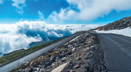 The byway visits Echo Lake Park, the Mount Goliath Natural Area, the Dos Chappell Nature Center, and Summit Lake Park on its way to the summit. A fee is charged to travel State Highway 5 to the summit and vehicles over 30 feet (9.1 m) long are not allowed, although they are allowed on State Highway 103 which reaches its highest elevation of 11,020 feet (3,359 m) at Juniper Pass. The byway connects to the Lariat Loop Scenic and Historic Byway at Bergen Park.
Route
The byway begins at the Idaho Springs Visitor Center. Take Exit 241 off Interstate 70 for 1 mile. Stop at the Visitor Center for information, then continue on Miner Street to 13th Avenue which is State Highway 103 and continues on State Highway 5 through a corridor between the Mount Evans Wilderness where it ends near the summit of Mount Evans.
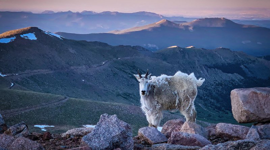 The byway is 28 miles (45 km) in length and gains over 7,000 feet (2,100 m) of elevation. Achieving a final elevation of 14,140 feet (4,310 m), this is the highest paved road in North America.
The road was originally planned by the Denver Mountain Parks system to link Summit Lake Park and Echo Lake Park to their lower altitude parks in the foothills.
Planning
As originally planned, the road ran from Bergen Park near Evergreen to Echo Lake, and then to the summit, while the road from Echo Lake down into Chicago Creek Canyon was a secondary branch. From the start, the road was planned in terms of the scenic vistas along the way.
The route was set by Frederick Law Olmsted, Jr., and for a while, between 1915 and 1920, it was to be the primary access road for a proposed National Park comprising much of what is now the Mount Evans Wilderness Area. There is a park fee charged if using parking lots and facilities along the upper portion of the byway. Prior to 2012, the Forest Service was charging anyone entering the highway at the entrance to Highway 5.
Summit Lake
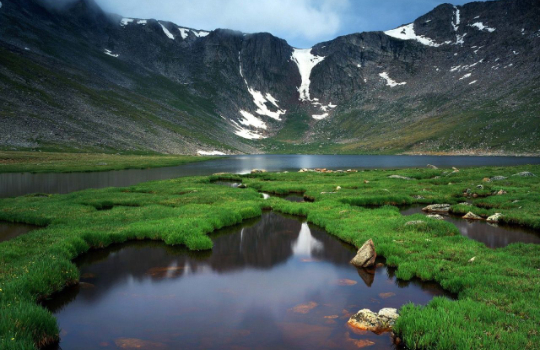 This portion of the byway is often narrow, with sudden dropoffs that have no guardrails. It is typically accessible from Memorial Day weekend through Labor Day, although the amount of access and specific dates vary depending on the weather and road conditions. This route was designated a National Forest Scenic Byway on July 1, 1993 by the US Forest Service and has also been designated a Colorado Scenic Byway by the Colorado Department of Transportation.
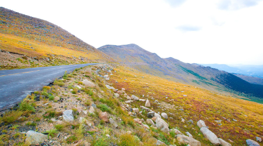 This high-altitude scenic drive climbs more than 7,000 feet in just 28 miles, reaching an altitude of 14,264 feet.
