Seattle is situated on an isthmus between Puget Sound (an inlet of the Pacific Ocean) and Lake Washington. It is the northernmost major city in the United States, located about 100 miles (160 km) south of the Canadian border. A major gateway for trade with East Asia, Seattle is the fourth-largest port in North America in terms of container handling as of 2021.
The Seattle area was inhabited by Native Americans for at least 4,000 years before the first permanent European settlers.[13] Arthur A. Denny and his group of travelers, subsequently known as the Denny Party, arrived from Illinois via Portland, Oregon, on the schooner Exact at Alki Point on November 13, 1851. The settlement was moved to the eastern shore of Elliott Bay and named "Seattle" in 1852, in honor of Chief Si'ahl of the local Duwamish and Suquamish tribes. Today, Seattle has high populations of Native, Scandinavian, Asian American and African American people, as well as a thriving LGBT community that ranks sixth in the United States by population.
Logging was Seattle's first major industry, but by the late 19th century, the city had become a commercial and shipbuilding center as a gateway to Alaska during the Klondike Gold Rush. Growth after World War II was partially due to the local Boeing company, which established Seattle as a center for aircraft manufacturing.
The Seattle area developed into a technology center from the 1980s onwards with companies like Microsoft becoming established in the region; Microsoft founder Bill Gates is a Seattleite by birth. Internet retailer Amazon was founded in Seattle in 1994, and major airline Alaska Airlines is based in SeaTac, Washington, serving Seattle's international airport, Seattle–Tacoma International Airport.
The stream of new software, biotechnology, and Internet companies led to an economic revival, which increased the city's population by almost 50,000 between 1990 and 2000. Seattle also has a significant musical history. Between 1918 and 1951, nearly two dozen jazz nightclubs existed along Jackson Street, from the current Chinatown/International District to the Central District. The jazz scene nurtured the early careers of Ray Charles, Quincy Jones, Ernestine Anderson, and others. Seattle is also the birthplace of rock musician Jimi Hendrix, as well as the origin of the bands Nirvana, Pearl Jam, Soundgarden, Heart, Alice in Chains, Foo Fighters, and the alternative rock movement grunge.
My wife and I visited this great city for a week in October 2021, exploring many parts of the Seattle inclduing Space Needle, Pike Market Place, Bainbridge Island, Chihuly Garden and Glass, Kerry Park, and Mount Rainier NP.

Bainbridge History
Bainbridge Island is a city and island in Kitsap County, Washington, United States, located in Puget Sound. The island is separated from the Kitsap Peninsula by Port Orchard, with Bremerton lying to the southwest. Bainbridge Island is a suburb of Seattle, connected via the Washington State Ferries system and to Poulsbo and the Suquamish Indian Reservation by State Route 305, which uses the Agate Pass Bridge.
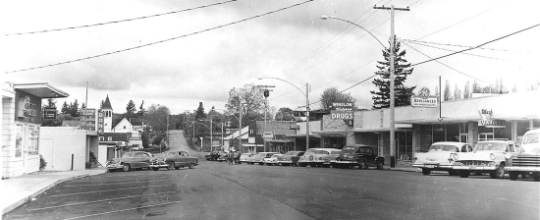
For thousands of years, members of the Suquamish people and their ancestors lived on the land now called Bainbridge Island.
There were nine villages on the island; these included winter villages at Port Madison, Battle Point, Point White, Lynwood Center, Port Blakely, and Eagle Harbor, as well as summer villages at Manzanita, Fletcher Bay, and Rolling Bay.
In 1792, English explorer Captain George Vancouver spent several days with his ship HMS Discovery anchored off Restoration Point at the southern end of Bainbridge Island while boat parties surveyed other parts of Puget Sound.
Vancouver spent a day exploring Rich Passage, Port Orchard, and Sinclair Inlet. He failed to find Agate Passage, and so his maps show Bainbridge Island as a peninsula. Vancouver named Restoration Point on May 29, the anniversary of the English Restoration, in honor of King Charles II.
In 1841, US Navy Lieutenant Charles Wilkes visited the island while surveying the Pacific Northwest. Lt. Wilkes named the island after Commodore William Bainbridge, commander of the frigate USS Constitution in the War of 1812. Settlers originally used Bainbridge Island as a center for the logging and shipbuilding industries. The island was known for huge and accessible cedars, which were especially in demand for ships' masts. The original county seat of Kitsap County was at Port Madison on the island's north end.
In 1855, the Suquamish tribe relinquished their claim to Bainbridge Island by signing the Point Elliott Treaty.[13] The Suquamish agreed to cede all of their territory (which included Bainbridge Island) to the United States in exchange for a reservation at Port Madison and fishing rights to Puget Sound.
Japanese Immigrants
The first generation of Japanese immigrants, the Issei, came in 1883. During World War II, Japanese-American residents of Bainbridge Island were the first to be sent to internment camps, an event commemorated by the Bainbridge Island Japanese American Exclusion Memorial, which opened in 2011.
They were held by the US government through the duration of the war for fear of espionage. A High-frequency direction finding (HFDF) station was established here by the Navy during the war. These radio intercept sites along the West Coast were used to track Japanese warships and merchant marine vessels as far away as the Western Pacific. The other West Coast stations were in California at Point Arguello, Point Saint George, Farallon Islands and San Diego.
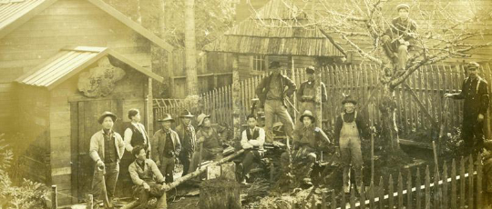
Since the 1960s, Bainbridge Island has become an increasingly affluent bedroom community of Seattle, a 35-minute ride away on the Washington State Ferries.
The city has occupied the entire space of Bainbridge Island since February 28, 1991, when the 1.5-square-mile (3.9 km2) city of Winslow (incorporated on August 9, 1947), annexed the rest of the island after a narrowly passed November 1990 referendum. It officially remained the city of Winslow for several months, until November 7, 1991 at which time the city of Winslow was renamed the city of Bainbridge Island.
Geography
Bainbridge Island was formed during the last ice age—13,000 to 15,000 years ago—when the 3,000-foot-thick (910 m) Vashon Glacier scraped out the Puget Sound and Hood Canal basins.
Bainbridge Island is located within the Puget Sound Basin, east of the Kitsap Peninsula, directly east of the Manette Peninsula and west of the city of Seattle.
The island is approximately 5 miles (8 km) wide and 10 miles (16 km) long, encompassing nearly 17,778 acres (27.778 sq mi; 71.95 km2), and is one of the larger islands in Puget Sound.
Bainbridge Island shorelines border the main body of Puget Sound, as well as Port Orchard Bay, a large protected embayment, and two high-current tidal passages, Rich Passage and Agate Pass.
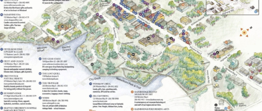
The island is characterized by an irregular coastline of approximately 53 miles (85 km), with numerous bays and inlets and a significant diversity of other coastal land forms, including spits, bluffs, dunes, lagoons, cuspate forelands, tombolos, tide flats, streams and tidal deltas, islands, and rocky outcrops.
The high point is 425-foot (130 m) Toe Jam Hill. On the Kitsap Peninsula, Bremerton and Poulsbo lie across the Port Orchard channel to the west, and the city of Port Orchard lies across Rich Passage to the south.
The island is quite hilly and hosts the Chilly Hilly bicycle ride every February.

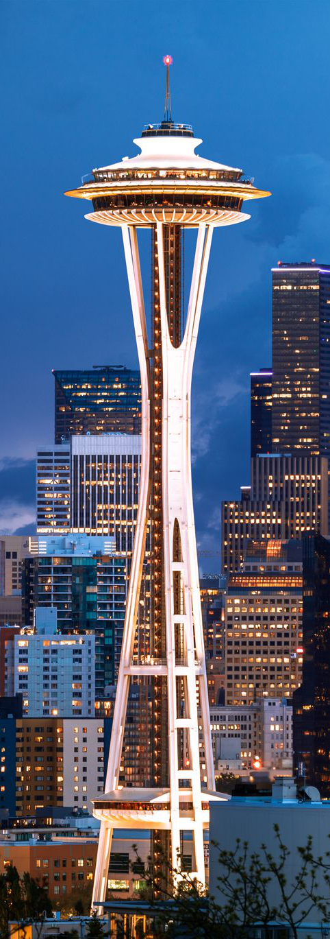
The Space Needle is an observation tower in Seattle, Washington, United States.
Considered to be an icon of the city, it has been designated a Seattle landmark. Located in the Lower Queen Anne neighborhood, it was built in the Seattle Center for the 1962 World's Fair, which drew over 2.3 million visitors.
The Space Needle was once the tallest structure west of the Mississippi River, standing at 605 ft (184 m). The tower is 138 ft (42 m) wide, weighs 9,550 short tons (8,660 metric tons), and is built to withstand winds of up to 200 mph (320 km/h) and earthquakes of up to 9.0 magnitude, as strong as the 1700 Cascadia earthquake.
The Space Needle features an observation deck 520 ft (160 m) above ground, providing views of the downtown Seattle skyline, the Olympic and Cascade Mountains, Mount Rainier, Mount Baker, Elliott Bay, and various islands in Puget Sound.
Visitors can reach the top of the Space Needle by elevators. It takes 41 seconds to reach the top in the elevators. On April 19, 1999, the city's Landmarks Preservation Board designated the tower a historic landmark.
The architecture of the Space Needle is the result of a compromise between the designs of two people, Edward E. Carlson and John Graham, Jr. The two leading ideas for the World Fair involved businessman Edward E. Carlson's sketch (on a napkin) of a giant balloon tethered to the ground (the gently sloping base) and architect John Graham's concept of a flying saucer (the halo that houses the restaurant and observation deck). Victor Steinbrueck introduced the hourglass profile of the tower.
The Space Needle was built to withstand wind speeds of 200 mph (320 km/h), double the requirements in the building code of 1962. The 6.8 Mw Nisqually earthquake jolted the Needle enough in 2001 for water to slosh out of the toilets in the restrooms. The Space Needle will not sustain serious structural damage during earthquakes of magnitudes below 9.1.
Also made to withstand Category 5 hurricane-force winds, the Space Needle sways only 1 in (25 mm) per 10 mph (16 km/h) of wind speed.
For decades, the hovering disk of the Space Needle was home to two restaurants 500 ft (150 m) above the ground: the Space Needle Restaurant, which was originally named Eye of the Needle, and Emerald Suite. These were closed in 2000 to make way for SkyCity, a larger restaurant that features Pacific Northwest cuisine. In 1993, the elevators were replaced with new computerized versions. The new elevators descend at a rate of 10 mph (16 km/h).
On December 31, 1999, a powerful beam of light was unveiled for the first time. Called the Legacy Light or Skybeam, it is powered by lamps that total 85 million candela shining skyward from the top of the Space Needle to honor national holidays and special occasions in Seattle.
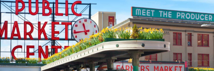
Pike Place Market is a public market in Seattle, Washington, United States. It opened on August 17, 1907, and is one of the oldest continuously operated public farmers' markets in the United States. Overlooking the Elliott Bay waterfront on Puget Sound, it serves as a place of business for many small farmers, craftspeople and merchants.
It is named for its central street, Pike Place, which runs northwest from Pike Street to Virginia Street on the western edge of Downtown Seattle. Pike Place Market is Seattle's most popular tourist destination and the 33rd most visited tourist attraction in the world, with more than 10 million annual visitors.
The Market is built on the edge of a steep hill and consists of several lower levels located below the main level. Each features a variety of unique shops such as antique dealers, comic book and collectible shops, small family-owned restaurants, and one of the oldest head shops in Seattle.
The upper street level contains fishmongers, fresh produce stands and craft stalls operating in the covered arcades. Local farmers and craftspeople sell year-round in the arcades from tables they rent from the Market on a daily basis, in accordance with the Market's mission and founding goal: allowing consumers to "Meet the Producer".
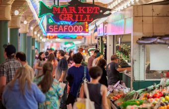 Pike Place Market is home to nearly 500 residents who live in eight different buildings throughout the Market. Most of these buildings have been low-income housing in the past; however, some of them no longer are, such as the Livingston Baker apartments.
The Market is run by the quasi-government Pike Place Market Preservation and Development Authority (PDA).

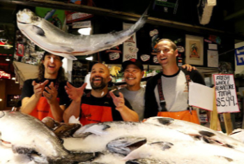
Located in Seattle’s Pike Place Market since 1930, Pike Place Fish Market has endured as the local favorite for fresh, wild, premium Pacific seafood.
In 1986, longtime owner John Yokoyama and his crew made a commitment to become world-famous by only sourcing the highest quality seafood, providing excellent customer service, and committing to making a difference in their community.
Now, internationally esteemed for its fresh seafood and in-person fish throwing, Pike Place Fish Market passionately stands by its pillars of excellence, committed to providing you with the world’s best seafood no matter where you are in the country. All of their seafood is 100% sustainable.
In 2018, four veteran Pike Place Fish Market fishmongers — Jaison Scott, Ryan Reese, Sam Samson, and Anders Miller — bought the business from Yokoyama. With over 80 years of combined experience at Pike Place, the new owners and their crew continue to honor the commitment to excellence that Yokoyama had so passionately envisioned.
Through its success, Pike Place Fish Market has rightfully achieved its “World Famous” title for its unmatched quality in sourcing the best seafood on the planet.

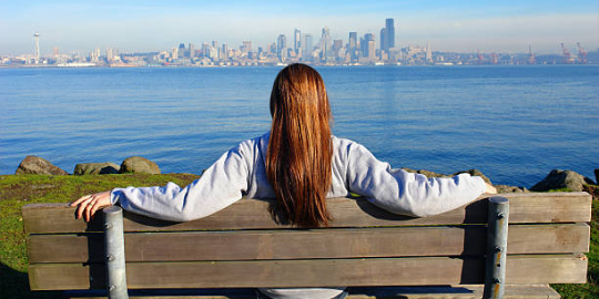
Alki Beach Park is a 135.9-acre (55.0 ha) park located in the West Seattle neighborhood of Seattle, Washington that consists of the Elliott Bay beach between Alki Point and Duwamish Head. It has a 0.5 miles (0.80 km) of beachfront, and was the first public salt-water bathing beach on the west coast of the United States. It is open daily from 4am to 11:30pm.
Alki Beach has a two and a half mile long pedestrian walkway, and in the summer is populated by beach volleyball players, sun worshipers, and beachcombers. Most of the beaches on Puget Sound are covered in rock and shells, but on Alki you can get sand between your toes, get some exercise, learn about Seattle’s earliest settlers, and take in a great view of the Seattle skyline.
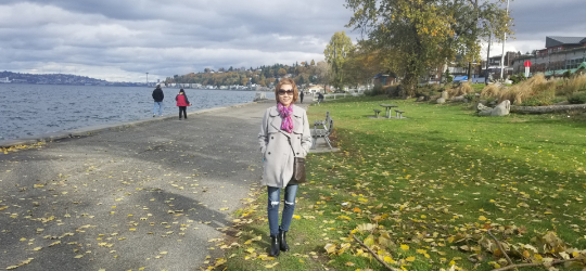
The beach has a replica of the Statue of Liberty that was installed in 1952. The Alki Point Monument memorializing Seattle's pioneer White settlers is also located in the park. Dogs are allowed in the park, but not on the beach, there is a $500.00 fine for pets on the beach.
The Denny party, Seattle’s first white settlers, arrived on Alki Beach in 1851. They were helped through their first winter by a band of the Duwamish people, led by Chief Seattle. The settlers named the area New York-Alki. Alki is a native word meaning “by and by”, and the settlers chose it to reflect their hope that the new settlement would grow to achieve the size and importance of New York City. After one winter camped on the beach, most of the party moved across Elliot Bay, to the less exposed shores of Seattle’s current waterfront.

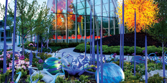
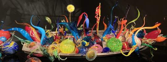
Chihuly Garden and Glass is an exhibit in the Seattle Center directly next to the Space Needle, showcasing the studio glass of Dale Chihuly.
It opened in May 2012 at the former site of the defunct Fun Forest amusement park.
The project features three primary components: the Garden, the Glasshouse, and the Interior Exhibits, with significant secondary spaces including a 90-seat café with additional outdoor dining, a 50-seat multi-use theater and lecture space, retail and lobby spaces, and extensive public site enhancements beyond the Garden. The 100-foot-long installation inside of the Glasshouse is one of Chihuly's largest suspended sculptures. Designed with the help of architect Owen Richards, the facility was awarded LEED silver certification from the USGBC.
Born in 1941 in Tacoma, Washington, Dale Chihuly was introduced to glass while studying interior design at the University of Washington. After graduating in 1965, Chihuly enrolled in the first glass program in the country, at the University of Wisconsin. He continued his studies at the Rhode Island School of Design (RISD), where he later established the glass program and taught for more than a decade. In 1968, after receiving a Fulbright Fellowship, he went to work at the Venini glass factory in Venice. There he observed the team approach to blowing glass, which is critical to the way he works today. In 1971, Chihuly cofounded Pilchuck Glass School in Washington State. With this international glass center, Chihuly has led the avant-garde in the development of glass as a fine art. His work is included in more than 200 museum collections worldwide. He has been the recipient of many awards, including twelve honorary doctorates and two fellowships from the National Endowment for the Arts.
Seattle’s waterfront is a glorious open-air promenade with a day’s worth of activities for all ages. Anchoring the boardwalk is the Seattle Aquarium (1483 Alaskan Way Pier 59), an iconic institution where you can watch its adorable sea otters frolic and float on their backs. After lunch at another Seattle institution, Ivar’s Acres of Clams (1001 Alaskan Way) on Pier 54, climb into a gondola on The Seattle Great Wheel (1301 Alaskan Way) and rise 175 feet above the earth for views of the sparkling Sound and Seattle skyline.
Exit the wheel and step into Miner’s Landing (Pier 57), a Gold Rush–era building with a carousel, an arcade, shops, and restaurants. A visit to the waterfront isn’t complete without a stop into Ye Olde Curiosity Shop (1001 Alaskan Way), home since 1899 to the macabre and kitschy, from skull-themed drinkware to replica shrunken heads. Spread out a picnic at Pier 62, or wander along the water up to Myrtle Edwards Park (3130 Alaskan Way). Alternatively, scale the Harbor Steps up to First Avenue for access to shops and museums, or climb the stairs up the back of Pike Place Market, where hole-in-the-wall restaurants with views of the water and mountains beckon.
Elliott Bay is a part of the Central Basin region of Puget Sound. It is in the U.S. state of Washington, extending southeastward between West Point in the north and Alki Point in the south. Seattle was founded on this body of water in the 1850s and has since grown to encompass it completely. The waterway it provides to the Pacific Ocean has served as a key element of the city's economy, enabling the Port of Seattle to become one of the busiest ports in the United States.
The Seattle Waterfront is one of the most iconic destinations in the city where you'll find shops, seafood, and stunning views of the tranquil Puget Sound. In addition to the shops and restaurants, you'll find several attractions here that make the waterfront a wholesome attraction packed with a full day's worth of opportunities if not more. Several piers dot the waterfront, and you can use them to venture out onto the water for more adventures if you like.
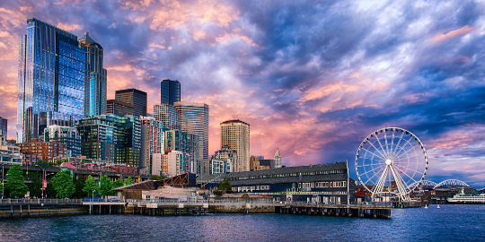 The first piece of Waterfront Park to open, Pier 62 is the city’s most scenic new cultural destination. Admire stunning views of Elliott Bay and the urban skyline, discover an eclectic range of activities, grab a bite from local food vendors, and open your imagination with public art and performances. It’s Seattle like you’ve never seen it.

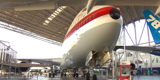
The Museum of Flight is a private non-profit air and space museum in the Seattle metropolitan area. It is located at the southern end of King County International Airport (Boeing Field) in the city of Tukwila, immediately south of Seattle. It was established in 1965 and is fully accredited by the American Alliance of Museums.
As the largest private air and space museum in the world, it also hosts large K–12 educational programs.
The museum attracts over 500,000 visitors every year, and also serves more than 140,000 students annually through its onsite programs: a Challenger Learning Center, an Aviation Learning Center, and a summer camp (ACE), as well as outreach programs that travel throughout Washington and Oregon.
In June 2010, the museum broke ground on a $12 million new building to house a Space Shuttle it hoped to receive from NASA, named the Charles Simonyi Space Gallery. The new building includes multisensory exhibits that emphasize stories from the visionaries, designers, pilots, and crews of the Space Shuttle and other space related missions.
The gallery opened to the public in November 2012.
Though the museum did not receive one of the four remaining Shuttles, it did receive the Full Fuselage Trainer (FFT), a Shuttle mockup that was used to train all Space Shuttle astronauts.[25] Because it is a trainer and not an actual Shuttle, small group (no more than six persons, minimum age 10, maximum height 6' 4") guided tours of the interior are available, for an extra charge.
The FFT began arriving in various pieces beginning in 2012. The cockpit and two sections of the payload bay arrived via NASA's Super Guppy.
During the 50th anniversary celebrations for Apollo 11 in 2019, the Museum of Flight hosted a traveling Smithsonian exhibit with the Apollo Command Module Columbia, which was used during the first moon landing.


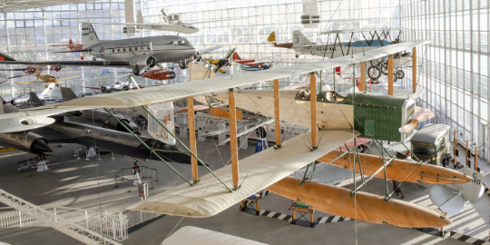
The Museum of Flight can trace its roots back to the Pacific Northwest Aviation Historical Foundation, which was founded in 1965 to recover and restore a 1929 Boeing 80A-1, which had been discovered in Anchorage, Alaska. The restoration took place over a 16-year period, and after completion, was put on display as a centerpiece for the museum.
In 1968, the name "Museum of Flight" first appeared in use in a 10,000-square-foot facility, rented at the Seattle Center. Planning began at this time for a more permanent structure, and preliminary concepts were drafted.
In 1975, The William E. Boeing Red Barn was acquired for one dollar from the Port of Seattle, which had taken possession of it after Boeing abandoned it during World War II.
 The 1909 all-wooden Red Barn, the original home of the company, was barged two miles (3 km) up the Duwamish River to its current location at the southwestern end of Boeing Field. Fundraising was slow in the late 1970s, and after restoration, the two-story Red Barn was opened to the public in 1983.
That year a funding campaign was launched, so capital could be raised for construction of the T.A. Wilson Great Gallery.
In 1987, Vice President George Bush, joined by four Mercury astronauts, cut the ribbon to open the facility on July 10, with an expansive volume of 3,000,000 cubic feet (85,000 m3). The gallery's structure is built in a space frame lattice structure and holds more than 20 hanging aircraft, including a Douglas DC-3 weighing more than nine tons.

Built in 1937, the landmark building was originally home to the Anderson Hardware store and was built by their staff, utilizing bricks salvaged from the old incinerator for the island’s Port Blakely Mill. Until the end of the Mill’s operations in 1922, those same bricks were fired thousands of times and took on a wide variety of tones, a richness that was passed on to the walls of the Anderson building.
When Pegasus threw open its doors to the little-changed building forty-some years later, the amazing aroma of fresh, hand-roasted coffee spilled out. Islanders were led by their noses to a funky new brick coffee house, hangout, and home-away-from-home. Many have been coming back ever since, and they are constantly joined by a mix of new friends, both young and old.

Snoqualmie Falls is a 268-foot (82 m) waterfall in the northwest United States, located east of Seattle on the Snoqualmie River between Snoqualmie and Fall City, Washington.
It is one of Washington's most popular scenic attractions and is known internationally for its appearance in the cult television series Twin Peaks. More than 1.5 million visitors come to the Falls every year, where there is a two-acre (0.8 ha) park, an observation deck, and a gift shop.
Most of the river is diverted into the power plants, but at times the river is high enough to flow across the entire precipice, which creates an almost blinding spray. High water occurs following a period of heavy rains or snow followed by warm rainy weather. This can occur during the rainy season which lasts from November through March. During high water, the falls take on a curtain form.
For the Snoqualmie People, who have lived since time immemorial in the Snoqualmie Valley in western Washington, Snoqualmie Falls is central to their culture, beliefs, and spirituality. A traditional burial site, to the Snoqualmie, the falls are "the place where First Woman and First Man were created by Moon the Transformer" and "where prayers were carried up to the Creator by great mists that rise from the powerful flow."[1] The mists rising from the base of the waterfall are said to serve to connect Heaven and Earth.
Mount Rainier
Mount Rainier National Park is an American national park located in southeast Pierce County and northeast Lewis County in Washington state. The park was established on March 2, 1899, as the fourth national park in the United States, preserving 236,381 acres (369.3 sq mi; 956.6 km2) including all of Mount Rainier, a 14,410-foot (4,390 m) stratovolcano.
The mountain rises abruptly from the surrounding land with elevations in the park ranging from 1,600 feet to over 14,000 feet (490–4,300 m). The highest point in the Cascade Range, Mount Rainier is surrounded by valleys, waterfalls, subalpine meadows, and 91,000 acres (142.2 sq mi; 368.3 km2) of old-growth forest. More than 25 glaciers descend the flanks of the volcano, which is often shrouded in clouds that dump enormous amounts of rain and snow.
Mount Rainier is circled by the Wonderland Trail and is covered by glaciers and snowfields totaling about 35 square miles (91 km2). Carbon Glacier is the largest glacier by volume in the contiguous United States, while Emmons Glacier is the largest glacier by area. Mount Rainier is a popular peak for mountaineering with some 10,000 attempts per year with approximately 50% making it to the summit.
 The purpose of Mount Rainier National Park is to protect and preserve unimpaired the majestic icon of Mount Rainier, a glaciated volcano, along with its natural and cultural resources, values, and dynamic processes. The park provides opportunities for people to experience, understand, and care for the park environment, and also provides for wilderness experiences and sustains wilderness values.
The entire park was designated a National Historic Landmark District on February 18, 1997, in recognition of the consistently high standard of design and preservation the park's National Park Service rustic-style architecture. The park contains 42 locations designated on the National Register of Historic Places, including four National Historic Landmarks.
The park's vegetation is diverse, reflecting the varied climatic and environmental conditions encountered across the park's 12,800-foot elevation gradient. More than 960 vascular plant species and more than 260 nonvascular plant species have been identified in the park.
History
Ninety-seven percent of the park is preserved as wilderness under the National Wilderness Preservation System as Mount Rainier Wilderness, a designation it received in 1988. It is abutted by the Tatoosh, Clearwater, Glacier View, and William O. Douglas Wildernesses.
The park was designated a National Historic Landmark on February 18, 1997, as a showcase for the National Park Service rustic-style architecture of the 1920s and 1930s, exemplified by the Paradise Inn and a masterpiece of early NPS master planning. As a Historic Landmark district, the park was administratively listed on the National Register of Historic Places.
 The name of the mountain itself in Lushootseed is "Tacoma", same as a nearby city in the Seattle metro area.
The earliest evidence of human activity in the area which is now Mount Rainier National Park, a projectile point dated to circa 4,000–5,800 BP (before present) found along Bench Lake Trail (the first section of Snow Lake Trail).
A more substantial archeological find was a rock shelter near Fryingpan Creek, east of Goat Island Mountain. Hunting artifacts were found in the shelter.
The shelter would not have been used all year round. Cultural affinities suggest the site was used by Columbia Plateau Tribes from 1000 to 300 BP.
In 1963 the National Park Service contracted Washington State University to study Native American use of the Mount Rainier area. Richard D. Daugherty lead an archeological study of the area and concluded that prehistoric humans used the area most heavily between 8000 and 4500 BP. Allan H. Smith interviewed elderly Native Americans and studied ethnographic literature. He found no evidence of permanent habitation in the park area.
The park was used for hunting and gathering and for occasional spirit quests. Smith also came to tentative conclusions that the park was divided among five tribes along watershed boundaries; the Nisqually, Puyallup, Muckleshoot, Yakama, and Taidnapam (Upper Cowlitz). Subsequent studies cast doubt on Smith's theory that the tribes had agreed upon boundaries before they entered into treaties with the United States in 1854–55.
